")
")
Archaeological sites


Nature


Culture, history, ethnography


The best day trips from Promina
Town of Drniš is situated south of Promina Mountain, in the center of Šibenik-Knin County, following the main county road from the county center Šibenik to hinterland, at whose northeast end is the city of Knin and Dinara Mountain. The term Drniš area is often used as a synonym for the area of Drniš and the neighboring municipalities of Promina, Ružić and Unešić. Drniš has 3 224 inhabitants, whilst the wider town area counts a total of 7 801 inhabitants. Town area covers 355 km2 and, besides town area, encompasses 27 small villages: Badanj, Biočić, Bogatić, Brištane, Drinovci, Drniš, Kadina Glavica, Kanjane, Kaočine, Karalić, Ključ, Kričke, Lišnjak, Miočić, Nos Kalik, Pakovo Selo, Parčić, Pokrovnik, Radonić, Sedramić, Siverić, Širitovci, Štikovo, Tepljuh, Trbounje, Velušić and Žitnić. Two rivers flow through wider town area - Krka and Čikola, and the area is surrounded by three mountains: Promina (1148m), Moseć (838m) and Svilaja (1508m). The climate here is sub-Mediterranean, with mild winters and hot summers.
More information about Drniš: tz-drnis.hr/en

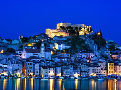
Located near the spring of the Krka River, 55 km from Šibenik and between the borders of Bosnia, Lika and Dalmatia, Knin has always been an important crossroad of the paths connecting the hinterland to the coast. As the most powerful fortified town in Dalmatia, the most prominent seat of Croatian kings and the excellent viewpoint that openly reveals entire Dalmatia, Knin has had considerable importance for all Croatian people, plainly seen in several grand nicknames like "The Royal Town", "The Key to Croatia" or "The Gate to Dalmatia", e.g.
Do not miss- Setting Foot on the Famous Knin Fortress and Exploring the Surrounding Area
- Visiting the Days of Zvonimir, a Historical Fair of Assorted Medieval Re-enactments
- See Lake Burum and the “Colourful” Lakes (Šarena jezera in Croatian)
- Enjoying Excellent Conditions for Extreme Sports on Imposing Dinara Mountain
More about Knin: tz-knin.hr/en
Šibenik is situated in the central part of the Croatian Adriatic Coast, in the picturesque and indented bay where the Krka River, one of the most beautiful karst rivers in Croatia enters the sea. Today Šibenik, with 46,332 inhabitants, is the administrative, political, economic and socio-cultural center of the Šibenik-Knin County.
Šibenik and Knin County has 242 islands, islets and above-sea reefs. The most numerous group of islands are the Kornati, which are distinguished by their remarkable beauty known throughout the world.
The Šibenik region is characterized by a Mediterranean climate with hot summers and dry and mild winters. In most parts of the Šibenik region, the most common winds are the bora-bura and the sirocco-jugo, and along the coastal belt there is even the refreshing onshore mistral-maestral.
Šibenik is famous for its cultural and historical sights and natural beauties, and boasts two monuments under the protection of UNESCO, the Cathedral of St. James and the St. Nicholas' fortress as well as the two national parks, Krka and Kornati. There are even three fortresses in the city: St. Michael's, Barone, St. John's and St. Nicholas' on the sea side with a beautiful view over the St. Anthony's Channel and the city of Šibenik.
More about Šibenik: sibenik-tourism.hr/en/
The Drniš City Museum was founded in 1960 thanks to the efforts and efforts of Nikola Adžija (1875-1972), who provided the basic preconditions for the establishment of the museum - the basic fund of objects and space in his birthplace. The generous donation of Ivan Meštrović (1883–1962) contributed to the realization of the long-standing desire to create a museum. At the request of N. Adžija, the artist predetermined almost thirty of his works for Drniš - 17 sculptures and 8 paintings. Although the museum was established as an independent institution, for a long time it did not have a professional staff or adequate space for exhibiting materials. In 1971 it became a component of the Drniš Cultural Center and changed its name to the Drniš Krajina Museum.
More about museum: Gradski muzej Drniš
During the Homeland War the Fortress area with Museum buildings was devastated and the collection was partially plundered. The Museum was reopened for the public in 1996, and its collection was displayed in the southern part of the Fortress in three refurbished buildings of the Belveder station. The permanent display consists of ethnographic, archaeological and (partly open air) cultural-historical and geological-palaeontological materials. The geological-palaeontological collection features geological specimens and fossils found in the surrounding area of Knin. The archaeological collection exhibits materials from the Knin area starting from prehistory, i.e. from the Mesolithic up to the late Middle Ages. Stone monuments dating from Antiquity, Middle and Late Middle Ages include architectural fragments (architraves, beams, column bases), altars, portraits of deities, stele, tegulae and so on.
The ethnographic display shows furniture, household accessories, objects made by traditional folk handicrafts (related to wool processing, pottery, basket-making and wood carving) and folk costumes from the area of Dalmatian Hinterland and Bukovica from the 19th and 20th centuries.
More about museum: kninskimuzej.hr/en

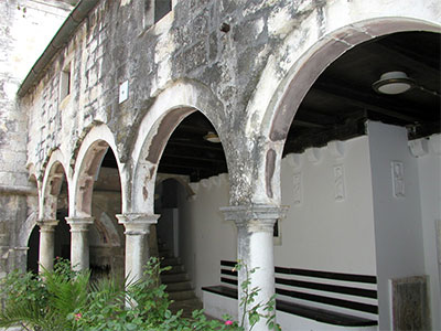
It is located on a gentle extension of the river Krka called Carigradska draga. It was built on the foundations of an older, Hermetic monastery, and is first mentioned in written documents in 1402 as an endowment of Jelena Šubić.
Monastery of St. Archangel is located in Constantinople Draga, in the middle of the canyon of the river Krka, and after him this part was named Arandjelovac.
It was built on the foundations of an old, hermitage monastery and is one of the most important spiritual centers of the Orthodox Dalmatian Diocese based in Šibenik.
Next to it is a church that has the shape of a Byzantine building with a dome. The bell tower was built in the Romanesque style. Below the church are the ancient Roman catacombs, which are open to visitors. The monastery has a large and rich library with many historical manuscripts, incunabula and rare books.
The Church of the Most Holy Redeemer is the last resting place of the great Croatian sculptor Ivan Meštrović and his closest family members: mother Marta, father Mate, brothers Marko and Petar, son Tvrtko and wife Olga. With the construction of this building, he fulfilled his intention to build a tomb for his family, and to give his native land a church in which, according to his wishes, the holy mass shall be held in the language of the people. For its construction (1926 -1930) he chose Paraćeva glavica, a small hill in the northwestern part of Petrovo polje, which belongs to the village of Ružić according to cadastral data, and is only a ten-minute walk from the house of Meštrović family in Otavice. The architectural project of Ivan Meštrović was realized by architects Harold Bilinić and Lavoslav Horvat and builder Marin Marasović.
More about resting place: mestrovic.hr/en
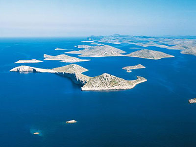
The Kornati National Park makes up most of the Kornati group of islands in the Croatian part of the Adriatic in central Dalmatia, west of Šibenik, in the Šibenik-Knin County. It was declared a national park in 1980 and then placed under protection. The total area of the park is about 220 km2 and consists of 89 islands, islets and reefs. Of the park’s area, only about a quarter is land, while the rest is marine ecosystem.
It is rich in natural and cultural features. The vertical cliffs of the "crown" of the Kornati islands facing the open sea are the most popular phenomenon of this park. They are also habitats of rare species.
The world of the Kornati submarine reveals some other fascinating stories. Kornati is an ideal destination for all those who are looking for a sunny oasis where the islands and the sea intertwine and where untouched, pure nature rests. You can reach Kornati only by boat, which usually departs from Murter, which is about a 40-minute drive from Promina.
Dinara Nature Park is the twelfth Croatian nature park. The area is 63,052 hectares (630.52 km2) of the Split-Dalmatia County and the Šibenik-Knin County, of which almost two thirds are located in the Split-Dalmatia County, and one third in the Šibenik-Knin County. Dinara Nature Park is the second largest Croatian nature park (the largest is the Velebit Nature Park). The Dinara Nature Park includes the Dinara massif (peaks: Dinara (Sinjal), Troglav and Kamešnica), the source and upper course of the Cetina River, the source of the Krka River, the Krčić River, and karst fields along the Cetina: - Hrvatačko, Paško and Vrličko fields.
The Dinara karst is an internationally recognized phenomenon that covers a much wider area, and it was named after the Dinara as a typical locality. It is the most valuable natural karst unit in the world, with deposits thicker than eight kilometers and with highly developed karst fields that contain all karst phenomena.
The Dinara area is extremely rich in endemic and endangered species. It is home to more than 1,000 plant species (one fifth of the total Croatian flora), of which 75 are national endemics. More than 20 endemic animal species are known, including one mammal - the Dinaric vole (Dinaromys bogdanovi). On the Dinara is the highest peak of the Republic of Croatia - Dinara, also known as Sinjal (1831 meters). In the area of the Dinara Nature Park there are 11 areas of the ecological network (2 areas for birds and 9 for species and habitats) so that 87% of the area of the Dinara Nature Park is also an area of the Natura 2000 ecological network. mountain yellow circle (Vipera ursinii macrops) in Croatia.
More about Dinara: en.wikipedia.hr/wiki/Dinara

Travelling along the Adriatic coast towards the northern Dalmatia, between two historical cities of Zadar and Šibenik, you will come across a natural phenomenon – the two equally beautiful and yet so very different shades of blue. On one side you will see the well indented Adriatic coast, famous for its alluring beauty and clear sea, and on the other side you will see the largest natural lake in Croatia.
Because of its rare natural habitats, fresh water springs and biodiversity, Vransko Lake and its surroundings have been declared a Nature Park on July 21st, 1999. The Park limits are between Pirovac and Pakoštane. It stretches across 57 km², 30,02km² of that being the lake area itself, which stretches in direction north-west to the south-east, parallel with the sea coast, from which it is, in some places, less than a kilometre apart. The lake is unique because of its position and characteristics, not only in Croatia, but in other parts of Europe too. It is, in fact, a karst valley filled with brackish water as well as cryptodepression, which means that a portion of the lake lies below sea level.
The dominating characteristic of the park is its special Ornithological reserve, which received its title in 1983 because of its well preserved huge reed-patch in the north-western part of the lake as well for its immense biodiversity, and extraordinary scientific and ecological value. The reserve has been included in the list of Important Bird Areas in Europe and became Ramsar site in 2013.
More about nature park: pp-vransko-jezero.hr/en

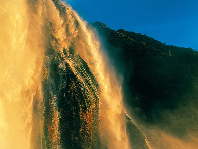
The six and second last waterfall, Roški slap, is exceptionally interesting due to its cascades, which the locals called the "necklace" due to the lush vegetation, mills and pillars, some of which have been restored, and much, much more.
The main waterfall is found at the end of the barrier where the Krka River falls 15 metres into Visovac Lake. Travertine formations at the waterfall are made up of caves, tufts, thresholds, small barriers and tapers. The tapers appear at the base of the main waterfall and represent the specificity of the Roški slap cascades. In 1910, on the right bank of the river, the Roški slap hydroelectric plant was constructed. Over the waterfall, there is a road that dates back to Roman times.
The canyon in this section widens into a funnel shape. The beginning of the travertine barriers is made up of a series of small cascades (called a “necklace” by the locals), while the middle portion is made up of numerous backwaters and islands. The length of the barrier is nearly 650 metres, at its widest is approximately 450 metres wide, with a total difference in altitude of 22.5 metres.
More info about : np-krka.hr
Skradinski buk is the seventh, final and longest travertine barrier on the Krka River. It is one of the most unusual and beautiful landscapes in Krka National Park.
Skradinski buk is the seventh, final, and longest travertine barrier on the Krka River. It is located approximately 13 kilometres downstream from Roški slap and a total of 49 kilometres downstream from the source. The growth of travertine barriers at Skradinski buk was caused by the unification of the waters of Krka River with the three kilometre lower current of the Čikola River at Roški slap, creating one of the most unusual and beautiful landscapes of the Krka National Park.
More info: np-krka.hr/en

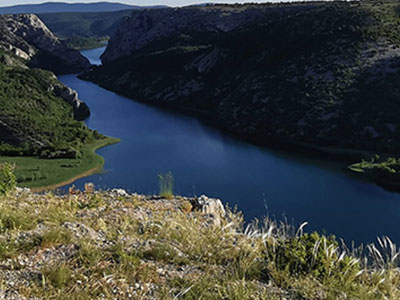
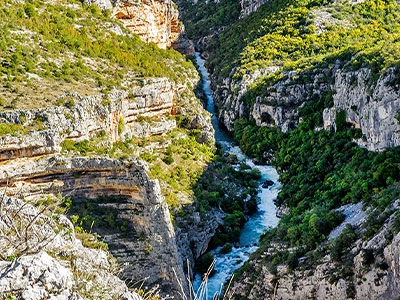
The Čikola River, with a total length of 46 km, is the longest tributary of the Krka. What makes it unique is its diverse character: it springs at the foot of Mount Svilaja near the hamlets of Mirlović Polje and Čavoglava, continues to flow peacefully through Petrovo Polje, and entering the canyon at the back of its course turns into a torrent, forming small lakes and continuing. canyon, flows into Krk. The watercourse and the canyon of the river Čikola, in the length of 13 km, from the end of Petrova polje to the border of the Krka National Park have been protected since 1967. as a significant landscape. This extremely attractive canyon, whose depth reaches up to 130 m, through which a fast karst river flows in winter and is almost completely dry in summer, offers many opportunities for hiking, free climbing and canyoning.
The flora and fauna of the canyon consists of 298 species of plants, 4 species of fish, 4 species of amphibians and 22 species of mammals, the most numerous of which are bats. There are several caves in the Čikola canyon, the most famous of which are the Hot Furnace and the caves in Brina. Traces of the presence of a man from the Late Paleolithic, around 18,000 BC, have been found here. Kr.
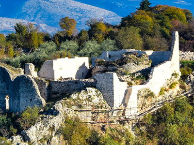
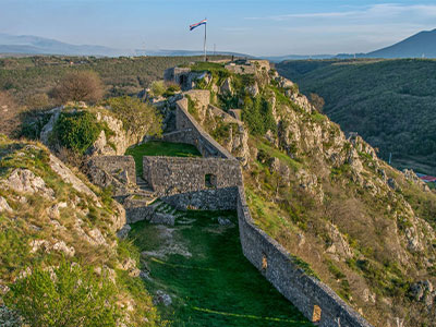
The canyon of the river Čikola stretches from the town of Drniš to the confluence with the river Krk above Skradinski buk. Its beginning and end is recognizable by the views of two medieval fortifications, Gradina, which dominates Drniš, and Ključica on the lower course of Čikola.
More about: zasticenapodrucja.com
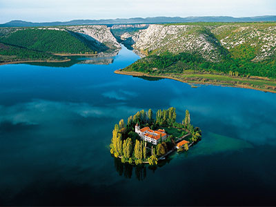
Visovac Island is situated in the middle of Visovac Lake.
The Franciscan Monastery of Our Lady of Mercy, and the Church of Our Lady of Visovac, have stood here since 1445. With their magnificent grounds, they form a unique entity.
Visovac Island is among the most important natural and cultural values of the Republic of Croatia. Since 1445, this has been the site of the Franciscan monastery of Our Lady of Mercy, and the Church of Our Lady of Visovac. With their magnificent grounds and surrounded by Visovac Lake, this forms a unique entity. During its stormy history, Visovac was and has remained an island of peace and prayer, and the Franciscan monastery is a fortress of spirituality and faith, and one of the key foundation stones of the survival of the Croats and the preservation of the Croatian national identity. The monastery possesses a significant archaeological collection, a collection of historical church linens and dishes, and a rich library with many valuable books and incunabula.
The centre of worship for the Mother of God at Visovac is the painting of the Virgin. According to the legend, the Franciscans brought the painting with them when they were forced to flee Bosnia during the Turkish invasions, and they found new shelter at Visovac. Due to the centuries of worship of Our Lady, the island of Visovac is also called Our Lady’s Island.
More about: np-krka.hr/en
Krčić is a ten-kilometer-long river that springs in strong karst springs at the foot of the Dinara, and its flow in places takes on the appearance of a deep and picturesque canyon. Along its bed there are travertine waterfalls, of which the largest and most beautiful is the last waterfall - Topoljski buk, below which the river Krka springs. The waterfall is 22 meters high, and is also known as "Veliki Buk" and "Krčić". Thanks to the 15 km long macadam road along the river Krčić, built by Emperor Napoleon more than 200 years ago, the romantic canyon of Krčić along the karst beauty, with its waterfalls and mills, is one of the most attractive excursion destinations.
More about: tz-knin.hr